Morbihan lighthouses: complete guide to the most beautiful lighthouses to see
MORBIHAN GUIDE
Morbihan lighthouses: the most beautiful to see and photograph
← Back to the complete guide to lighthouses in Brittany
← See also lighthouses in Finistère
Morbihan is perhaps the Breton department that offers lighthouses their most contrasting setting. On one side, the Gulf of Morbihan - an almost silent inland sea of seemingly gentle waters. On the other, the brutality of the Côte Sauvage, the rough seas between Quiberon and Houat, and the cliffs of Belle-Île battered by the Atlantic.
Belle-Île-en-Mer alone has three lighthouses. Goulphar towers 92 metres above the sea. Les Poulains guards the north-western tip of the island. La Teignouse, offshore, has been guarding the passage to Belle-Île since 1845 - it is the oldest active lighthouse in the département. Further east, Port-Navalo marks the entrance to the Gulf, and Pen Lan watches over the Vilaine estuary.
I've had the privilege of photographing these magnificent buildings for a long time, often in difficult conditions. Each time, they remain fascinating and impressive subjects for me. Follow me in this article to discover these stone giants of Morbihan.

Things to remember
Number
A dozen headlights
Morbihan has around ten main maritime lighthouses, as well as numerous other lights and beacons.
Belle-Île
3 headlights
Goulphar, les Poulains and Kerdonis form a natural triangle around the island.
Power
Goulphar
Perched 92 m above the sea, its light reaches 27 miles.
History
Port-Navalo
Saved from destruction in 1944 by the famous argument of the engineer Le Net.
Access
Easy
Several lighthouses are accessible by car or on foot, more easily than some of the lighthouses in Finistère.
Atmosphere
Lights
The light is often warmer at the end of the day, between the Gulf and the open Atlantic.
Map of Morbihan lighthouses
The map below will help you locate the lighthouses of Morbihan before planning your route. It immediately illustrates the geographical logic of the department: the three lighthouses on Belle-Île form a natural triangle around the island, The Quiberon peninsula is home to two other sites on the edge of the bay, and the rest of the coast stretches eastwards to the mouth of the Vilaine.
In practice, you can't tour the Morbihan in a single loop. The easiest way is to spend a whole day on Belle-Île and half a day on the Quiberon peninsula, then follow the east coast towards Port-Navalo and Pen Lan.
The interactive map loads only when clicked, to keep the page speeding up.
The lighthouses of Belle-Île-en-Mer
Belle-Île-en-Mer is the largest island in Brittany. It has three major lighthouses: Goulphar on the west coast, Les Poulains to the north-west and Kerdonis to the east. These three sites can be reached by bike.
Goulphar lighthouse - Belle-Île-en-Mer
Commissioned in 1835 to designs by Augustin Fresnel in Bangor, the Goulphar lighthouse is a double 52.25 m granite tower, perched 92 m above the sea. Its 247 steps lead up to an unobstructed view of up to 27 miles. It is one of the most powerful lighthouses in Brittany.
It now houses a museum dedicated to lighthouses and beacons, and serves as a remote control centre for the other lighthouses in Morbihan. Pen Lan has been remotely controlled since 1995. The Goulphar lighthouse is also at the heart of a current heritage issue: In Bangor, an association was set up in 2025 to bring together residents of Bellil who are concerned about the future of the building and its surroundings. Find out more about the Goulphare association.

Poulains lighthouse - Belle-Île-en-Mer
Inaugurated on 15 September 1868 at the north-western tip of Belle-Île, this 18 m lighthouse is built on an islet that is naturally separated from the island at high tide. Since the installation of 32 m² of photovoltaic solar panels, it has been self-sufficient in energy and is now open to the public.
At the Pointe des Poulains, the fort acquired by Sarah Bernhardt in 1894 was one of her havens in Bellon. For nearly thirty years, until 1922, she spent her summers there and welcomed many of the leading figures of her time, facing one of Belle-Île's most stunning seascapes.

Kerdonis lighthouse - Belle-Île-en-Mer
Brought into service on 1 June 1879 at the eastern tip of Belle-Île, this lighthouse is linked to one of the most famous acts of courage in the history of Breton lighthouse keepers. On 18 April 1911, lighthouse keeper Alexandre Matelot died suddenly while on duty. His wife and children operated the partially dismantled mechanism by hand throughout the night - without training, without respite, until the morning.
This act was hailed by the national and international press. The chansonnier Théodore Botrel, who celebrated maritime Brittany with a documentary precision that was rare at the time, immortalised it in a song.
Quiberon peninsula and bay
The Quiberon peninsula and the bay around it are home to three lighthouses of very different characters. Port-Maria closes off the Côte Sauvage to the south. Port-Haliguen, now deactivated, faces Carnac from the harbour. La Teignouse, offshore, has marked the passage between Quiberon and the island of Houat since 1845.

Port-Maria lighthouse - Quiberon
Built in 1892 to the south of the Quiberon peninsula, this 24.8 m white cylindrical tower with a green lantern marks the end of the Côte Sauvage. It is now surrounded by the town's buildings and cannot be visited.
The lighthouse has long accompanied the transformations of the port. It has lived through the era of fishing, then that of maritime links and a more lively, traveller-oriented district. This is undoubtedly what gives it its special place in the Quiberon landscape today.

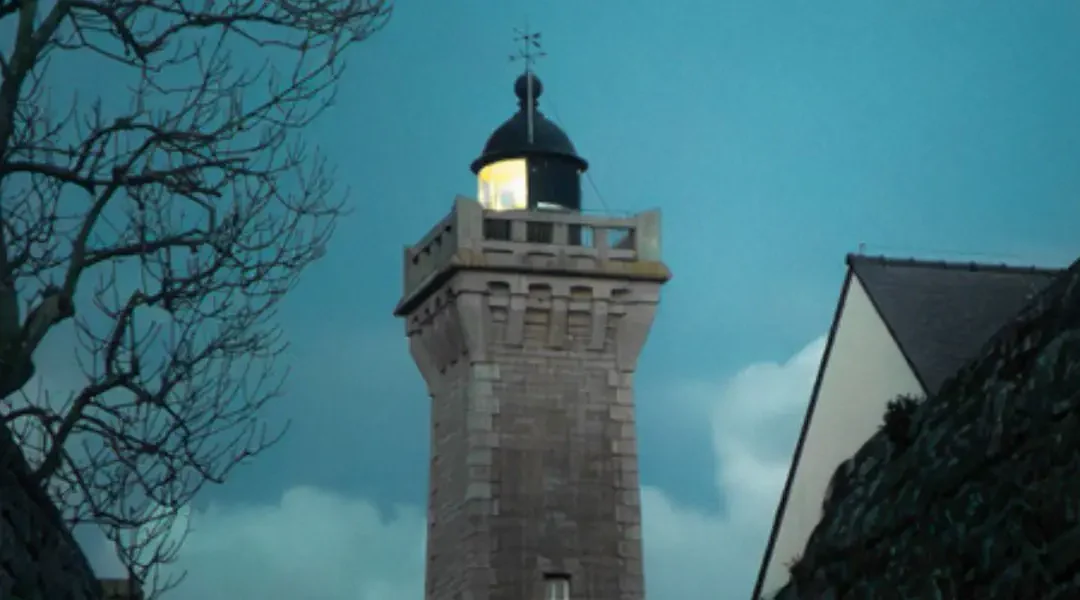
Port-Haliguen lighthouse - Quiberon
Brought into service in 1856 at the entrance to Quiberon Bay opposite Carnac, this 11.30 m white cylindrical tower with a green lantern guided sailors for more than 110 years before being decommissioned in the 1970s. Its caretaker's house now houses a cultural centre. The lighthouse can be visited during the Heritage Days.
I had the chance to see it up close in September 2025, during a week-long exhibition at the Maison du Phare. At the time, a resident of the peninsula told me this phrase, which says a lot about Quiberon: «In Quiberon, you don't just pass through, you come here». It's all there: the discreet charm of a secluded spot, rich in well-guarded treasures such as the Port-Haliguen lighthouse.

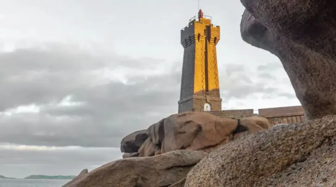
Teignouse lighthouse - Off Quiberon
La Teignouse is an obvious part of the Quiberon skyline. Standing in the sea as an extension of Le Conguel, this lighthouse, commissioned in 1845, has watched over the exit to the bay for almost two centuries.
Behind this familiar silhouette lies an innovative lighthouse, which served as a pilot light in 1892 before being automated in 1983. It's not open to the public, but it's an integral part of the peninsula's maritime identity.
Gulf of Morbihan, east coast and islands
This area is the most geographically dispersed, but it includes some of the lighthouses with the deepest roots in local history. Port-Navalo has been guarding the entrance to the Gulf since 1895. Pen Lan marks the mouth of the Vilaine. Kernevest, extinguished in 2012, preserves the memory of forty years of female presence. The Grands Cardinaux keep watch off Hoëdic.

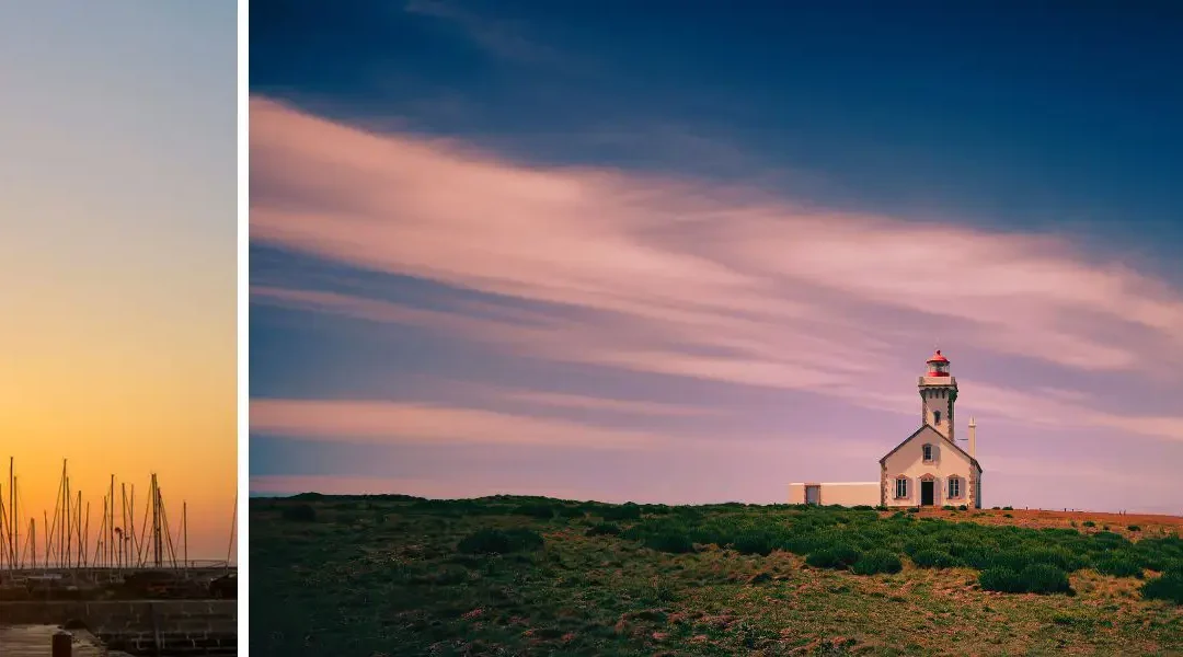
Port-Navalo lighthouse - Arzon
Built in Arzon at the entrance to the Gulf of Morbihan, this 19 m cylindrical lighthouse was brought into service in 1895. In 1944, the occupying forces planned to dynamite it, as they had done with so many Breton lighthouses. It was the engineer Le Net who convinced them - with an argument whose force has not aged a day:
«Lighthouses belong to no one, for they serve to save the lives of sailors of all nations.»
- Le Net engineer, 1944
And the lighthouse is still there!

Pen Lan lighthouse - Billiers
Built in 1882 and commissioned in 1888 at the mouth of the Vilaine, on the Pointe de Pen Lan in Billiers, This 17.93 m lighthouse has long marked the entrance to the estuary. Since 1955, it has emitted a light with two occultations every six seconds, before being automated in 1995 and then remotely controlled from the Goulphar lighthouse in Belle-Île-en-Mer.
The history of the lighthouse can also be told from a woman's perspective. Its last keeper, Eulalie Le Marchand, worked there until 1995, when the site was automated. She looked after the optics, made sure the light was working properly and kept an eye on a number of neighbouring beacons, including Kervoyal and Basse-Bertrand. This daily presence is a reminder that before automation, a lighthouse relied not only on technology, but also on constant human attention. It's a reminder of the end of the world, of a patient, precise and invisible profession that was so useful.

Kernevest lighthouse - Saint-Philibert
Built in 1855 in Saint-Philibert to guide ships towards La Trinité-sur-Mer, the Kernevest lighthouse stood at the entrance to the river at Crac'h before it was shut down in 2012, its horizon gradually closing in with the buildings and trees.
Anna Le Bail was the lighthouse keeper for forty years, from 1925 to 1965, continuing a long-standing family tradition. Her presence remains attached to the site, as a reminder of a time when this small lighthouse still lived to the rhythm of a daily vigil.

Grands Cardinaux Lighthouse - Off Hoëdic
The Grands Cardinaux lighthouse, to the south-east of Hoëdic, marks the approach to Quiberon Bay. Classified as a historic monument in 2020, it also owes a great deal to the commitment of a local association that fought for its restoration and for this «Hoëdic lighthouse» to regain its rightful place in the maritime landscape.
Art photography in Brittany
See my artistic photographs of Brittany
Shipwrecks, forests, lighthouses, the coasts of Morbihan and Finistère... A selection of limited edition prints to bring these landscapes home.
See photos of Bretagne ↗Each print is numbered and comes with a certificate of authenticity. Framing available on request, free delivery.
Morbihan lighthouses in brief
This table summarises the main lighthouses in Morbihan, their area, access and what makes them unique.
| Headlight | Zone | Height | Access | Visitable | What makes it unique |
|---|---|---|---|---|---|
| Goulphar | Belle-Île | 52,25 m | Ferry + island | Yes, museum | Double tower, 92 m above sea level |
| Foals | Belle-Île | 18 m | Ferry + island | Yes | Sarah Bernhardt, 30 summers in the nearby fort |
| Kerdonis | Belle-Île | Lighthouse | Ferry + island | No | Heroic gesture by the Matelot family (1911) |
| Port-Maria | Quiberon | 24,8 m | Route | No | End of the Côte Sauvage |
| Port-Haliguen | Quiberon | 11,30 m | Route | JEP | Deactivated, cultural centre in the house |
| Teignouse | Large Quiberon | 16,35 m | Coast / ferry view | No | In service since 1845 |
| Port-Navalo | Morbihan Gulf | 19 m | Route | No | Saved in 1944 by the engineer Le Net |
| Pen Lan | Mouth Vilaine | 17,93 m | Route | No | Remote-controlled from Goulphar |
| Kernevest | Saint-Philibert | ~15 m | Route | No | Off 2012, 40 years of caretaking |
| Grand Cardinals | Large Hoëdic | 27 m | Boat | No | Historic Monument 2020 |
The heights and dates mentioned are given for information only and may be subject to slight variations depending on the historical sources available.
Practical info
Here are some guidelines for organising your lighthouse visits in Morbihan, depending on the area and the season.
| Zone | Access | Best moment | Photo advice |
|---|---|---|---|
| Belle-Île-en-Mer | Ferry from Quiberon (approx. 45-50 min) | Spring, autumn | Goulphar in low evening light |
| Quiberon peninsula | Route | All year round | Port-Maria from the sea in winter |
| Gulf of Morbihan & east coast | Car + GR 34 footpaths | April-September | Port-Navalo at ebb tide |
| Offshore (Teignouse, Grands Cardinaux) | Ferry or boat | Summer | From the bridge of the Quiberon-Belle-Île ferry |
2-day itinerary - Morbihan lighthouses
A simple itinerary combining Belle-Île, Quiberon, the Gulf of Morbihan and the Vilaine estuary in two days.
Day 1 - Belle-Île-en-Mer
Take the first ferry from Quiberon (about a 50-minute crossing to Le Palais). Arrive at Le Palais and take the car or bike to the Goulphar lighthouse in Bangor. Spend the morning exploring the site, climbing the 247 steps and enjoying the view 92 m above the sea.
In the afternoon, head for the Pointe des Poulains to the north-west: the islet, the rocks and the natural foreground towards the lighthouse. At the end of the day, head east towards Kerdonis, where the golden light falls on the lighthouse at the tip of Belle-Île. Overnight on Belle-Île.
Day 2 - Quiberon, gulf and east coast
Return to the mainland by morning ferry. Morning tour of the Quiberon peninsula: Port-Maria lighthouse to the south, at the end of the Côte Sauvage, then Port-Haliguen lighthouse around the harbour.
Then on to the Gulf: Port-Navalo in the middle of the day, the Pointe d'Arzon and the whirlpools at the entrance to the Gulf at ebb tide. Finish at Pen Lan in Billiers in the late afternoon, with the evening light over the Vilaine estuary.
My most beautiful photographs of lighthouses
Some of these lighthouses are part of my photographic work. In my limited edition collection of photographs of Finistère , you will find the Tourelle des Perdrix, but also the Four lighthouse caught in the violence of the swell.
These photographs are available in limited edition of 30, signed and numbered with a certificate of authenticity. Framing is available on request, and delivery is free.
Cap Fréhel Lighthouse — limited edition art print.

Tourelle des Perdrix — Limited edition art print.

Phare du Four — Limited edition black and white art print.

Storm Justine — limited edition art print.
If you're fascinated by lighthouses in the middle of a storm, I invite you to discover my Storm guide to Brittany.
FAQ
How many lighthouses are there in Morbihan?
Morbihan has around ten main lighthouses. Belle-Île-en-Mer alone has three: Goulphar, les Poulains and Kerdonis.
Where can I find a map of Morbihan lighthouses?
The interactive map in this article locates all the main lighthouses in the département, from Belle-Île to the mouth of the Vilaine.
What is the most beautiful lighthouse in Morbihan?
Goulphar, in Belle-Île-en-Mer, is the most impressive with its double granite tower and its position 92 m above the sea. For photography, the Poulains offer an exceptional setting with their islet and rocks.
Can you visit the lighthouses in Morbihan?
Goulphar can be visited in season with its museography. Port-Haliguen is open during the Heritage Days. The other lighthouses in Morbihan are not open to the public, but are accessible from coastal paths.
Which Morbihan lighthouse to photograph first?
Goulphar for the unique architecture of its double tower. Les Poulains for its landscape and history. Port-Navalo for the light on the gulf at ebb tide.


")